- YY
- Day of the month (UTC), with 01 indicating the first day, 02 the second
day,etc. on which the actual time of observation falls
- MM
- Month of the year (UTC), i.e. 01=January; 02=February, etc.
- J
- Units digit of the year (UTC), i.e. 1994 = 4
- GGgg
- Time of observation, in hours and minutes (UTC)
(In BATHY and TESAC, GGgg is the time of launching the bathythermograph.)
- Qc
- Quadrant of the globe.
|
Code figure |
Latitude |
Longitude |
|
1 |
North |
East |
|
3 |
South |
East |
|
5 |
South |
West |
|
7 |
North |
West |
Note: The choice is left to the observer in the following cases: When
the ship is on the Greenwich meridian or the 180th meridian (LoLoLoLo =
0000 or 1800 respectively):
Qc = 1 or 7 (northern hemisphere) or
Qc = 3 or 5 (southern hemisphere);
When the ship is on the Equator (LaLaLa = 000):
Qc = 1 or 3 (eastern longitude) or
Qc = 5 or 7 (western longitude).
- LaLaLaLa
- Latitude, in thousandths of a degree
- LoLoLoLoLo
- Longitude, in thousandths of a degree
- iu
- Indicator for units of wind speed and type of instrumentation
Code
figure |
Units used |
Instruments certified or otherwise |
|
0 |
Metres per second |
Land stations, and ships with certified instruments |
|
1 |
Knots |
Land stations, and ships with certified instruments |
|
2 |
Metres per second |
Ships with uncertified instruments |
|
3 |
Knots |
Ships with uncertified instruments |
- dd
- True dirction, in tens of degrees, from which wind is blowing
        Code
        figure
        00 Calm
        01 5-14
        02 15-24
        03 25-34

        etc. etc.

        36 355-4
        99 Variable, or all directions or unknown or waves
           confused, direction indetermininate
- ff
- Wind speed, in units indicated by iu
- sn
- Sign of the data
code figure 0 Positive or zero 1 Negative
- TTT
- Air temperature, in tenths of a degree Celsius, its sign being given
by sn
- k1
- Indicator for digitization
Code figure 7 Values at selected depths (data points fixed by the
        instrument or selected by any other method) 8 Values at significant depths
        (data points taken from traces at significant depths)
- k2
- Method of salinity/depth measurement
Code figure 0 No salinity
  measured 1 In situ sensor, accuracy better than 0.02 per mill 2 In situ
  sensor, accuracy less than 0.02 per mill 3 Sample analysis
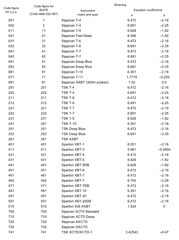
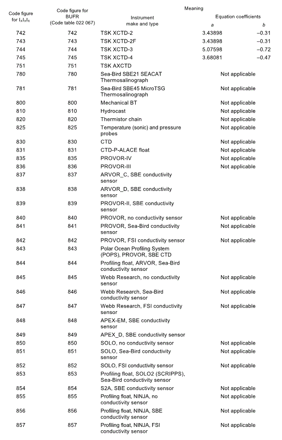
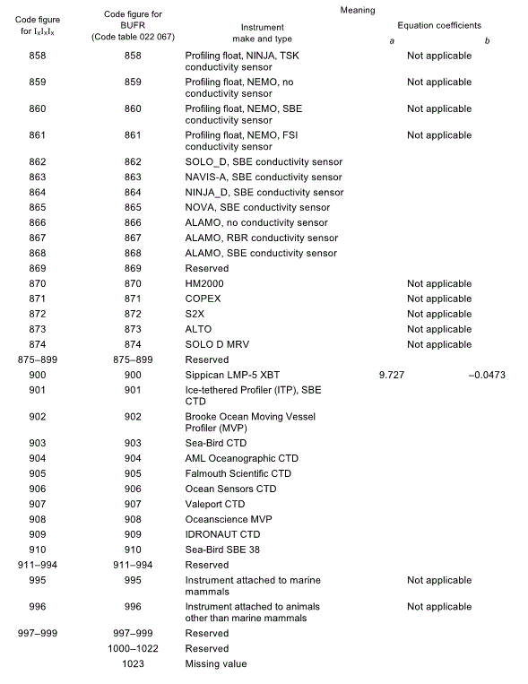
IxIxIx
- Instrument type for XBT, with fall rate equation coefficients. (When
the first group of the report is JJXX, this group is not reported.)


Notes:
(1) The depth is calculated from coefficients
a and b and the time t, as follows:
z = at + 10-3 bt2.
(2) All unassigned numbers are reserved.
- XRXR
- Recorder type (When the first group of the report is JJXX, this group
is not reported.)

- z0z0z0z0
z1z1z1z1
znznznzn
- Selected and/or significant depths, in metres, starting with the
surface.
- T0T0T0T0
T1T1T1T1
TnTnTnTn
- Teperatures, in hundredths of a degree Celsius, at either significant
or selected depths starting with sea surface
For negative temperatures, 5000 shall be added to the absolute value of
the temperature in hundredths of a degree Celsius.
- S0S0S0S0
S1S1S1S1
SnSnSnSn
- Salinity, in hundredths of a part per thousand, (practical salinity)
at either significant or selected depths starting with sea surface.
- 00000
- The group 00000 shall be included only when the temperature (salinity)
at the lowest depth of the sounding, which is (are) reported in the last
groups of the section, is (are) actually the bottom layer temperature (salinity).
- k6
- Method of removing the velocity and motion of the ship or buoy from
current measurement
Code
figure |
|
|
|
0 |
Ship's motion removed by averaging |
Ship's velocity removed by bottom tracking |
|
1 |
Ship's motion removed by motion compensation |
|
2 |
Ship's motion not removed. |
|
3 |
Ship's motion removed by averaging. |
Ship's velocity removed by navigation |
|
4 |
Ship's motion removed by motion compensation. |
|
5 |
Ship's motion not removed. |
|
6 |
Doppler current profiling method not used. |
|
7-9 |
Reserved |
Note: Code figures 0, 1, 2 and 6 are also used for drifting buoys.
- k4
- Period of current measurement (drift method)
Code figure 1 1 hour
  or less 2 More than 1 hour but 2 at the most 3 More than 2 hours but 4
  at the most 4 More than 4 hours but 8 at the most 5 More than 8 hours but
  12 at the most 6 More than 12 hours but 18 at the most 7 More than 18 hours
  but 24 at the most 9 Drift method not used
- k3
- Duration and time of current measurement (vector or Doppler current
profiling method)
Code
figure |
|
|
|
1 |
Instantaneous |
between H-1 and H |
|
2 |
Averaged over 3 minutes or less |
|
3 |
Averaged over more than 3 minutes, but 6 at the most |
|
4 |
Averaged over more than 6 minutes, but 12 at the most |
|
5 |
Instantaneous |
between H-2 and H-1 |
|
6 |
Averaged over 3 minutes or less |
|
7 |
Averaged over more than 3 minutes, but 6 at the most |
|
8 |
Averaged over more than 6 minutes, but 12 at the most |
|
9 |
Vector or Doppler current profiling method not used |
Note: H = time of observation.
- d0d0
d1d1
dndn
- True direction, in tens of degrees, towards which sea current at selected
and/or significant depths starting with the surface is moving
  Code
  figure
  00 Calm
  01 5-14
  02 15-24
  03 25-34

  etc. etc.

  36 355-4
  99 Variable, or all directions or unknown or waves
     confused, direction indetermininate
- c0c0c0
c1c1c1
cncncn
- Speed of the current, in centimetres per second, at selected and/or
significant depths starting with sea surface
- ZdZdZdZd
- Total water depth, in meters.
- D.....D
- Ship's call sign consisting of three or more alphanumeric characters
- A1
- WMO Regional Association area in which buoy, drilling rig or oil- or
gas-production platform has been deployed (1 - Region I; 2 - Region II,
etc.)
- bw
- Sub-area belonging to the area indicated by A1

- nbnbnb
- Type and serial number of buoy


