GTSPP Data Product CentreGTSPP Data Product Centre
GTSPP Data Product Centre for the North Pacific Region hosted by the Japan Meteorological Agency
Jrs Canis(C4LN2), PX40
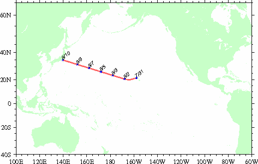
Observation period : 2013/7/31 to 2013/8/10
Observation period : 2013/7/31 to 2013/8/10
This page shows results for the PX40 line based on monitoring by the Jrs Canis and comparison with the result of assimilation by MOVE-NP.
Overall statistics
| Number of profiles | Number of data | AVE | RMSD | MAXD | MIND |
|---|---|---|---|---|---|
| 177 | 58854 | -0.02 | 1.31 | 11.67 | -6.78 |
Abbreviations in the table indicate:
AVE: average difference (observation value minus assimilation value)
RMSD: root mean square of difference
MAXD: maximum difference
MIND: minimum difference
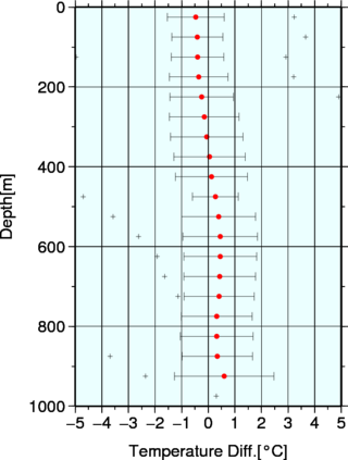
Statistics for each depth range
| Depth range | Number of data | AVE | RMSD | MAXD | MIND |
|---|---|---|---|---|---|
| 0-50 | 4412 | -0.47 | 1.07 | 3.23 | -6.78 |
| 50-100 | 4400 | -0.41 | 0.96 | 3.66 | -5.49 |
| 100-150 | 4400 | -0.40 | 0.99 | 2.92 | -4.97 |
| 150-200 | 4400 | -0.36 | 1.10 | 3.21 | -5.51 |
| 200-250 | 4400 | -0.25 | 1.19 | 4.90 | -5.99 |
| 250-300 | 4400 | -0.15 | 1.31 | 6.30 | -6.16 |
| 300-350 | 4400 | -0.06 | 1.36 | 7.32 | -6.32 |
| 350-400 | 4400 | 0.05 | 1.34 | 8.26 | -6.16 |
| 400-450 | 4400 | 0.12 | 1.35 | 8.90 | -5.69 |
| 450-500 | 4400 | 0.27 | 0.86 | 9.47 | -4.70 |
| 500-550 | 1760 | 0.39 | 1.39 | 10.08 | -3.58 |
| 550-600 | 1760 | 0.45 | 1.40 | 10.58 | -2.62 |
| 600-650 | 1760 | 0.45 | 1.37 | 10.91 | -1.92 |
| 650-700 | 1752 | 0.43 | 1.35 | 11.13 | -1.64 |
| 700-750 | 1750 | 0.41 | 1.32 | 11.22 | -1.14 |
| 750-800 | 1750 | 0.32 | 1.33 | 11.28 | -5.39 |
| 800-850 | 1750 | 0.32 | 1.37 | 11.40 | -5.09 |
| 850-900 | 1719 | 0.34 | 1.33 | 11.53 | -3.69 |
| 900-950 | 785 | 0.60 | 1.87 | 11.61 | -2.36 |
| 950-1000 | 51 | 6.58 | 1.31 | 11.66 | 0.30 |
Results of QC
A total of 177 profiles (80625 data, reported by BATHY or TESAC) were received from the Jrs Canis.
The results of JMA quality control are as follows.
The results of JMA quality control are as follows.
- Grounded test
- Position on land test
- Regional range test
- Gradient test
Error data: 0 of 80625
On land: 0 of 177
Invalid position: 0 of 177
Error data (low): 4 of 80625
Error data (high): 20 of 80625
Error data: 274 of 80625
For datails of JMA's quality control procedures, please refer to this page.
Summary of QC
- Some erroneous profiles are detected by JMA's automated quality control procedures. These are checked by the regional range test and the gradient test. The main cause will be "hitting bottom" of XBT.
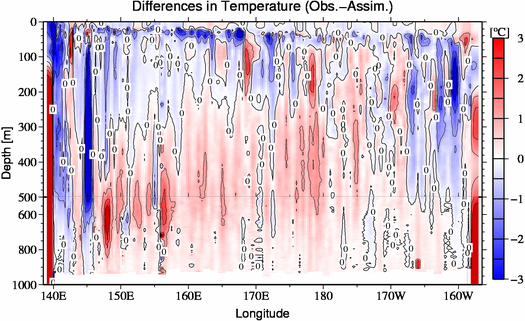
- Among the data that passed JMA's automated quality control procedures, some "hitting bottom" data are found in the seas near the Boso Peninsula and adjacent Hawaii Islands (Refer to concerned figures (A) and (B)). The topography used our grounded test is too rough to catch the error.
- Two of the observations around 30.7°N, 156°E are considered to be erroneous data (Refer to concerned figures (C)).
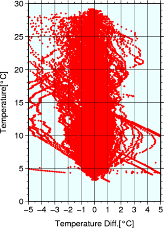
- With the exception of the above errors and differences, there was a small warm bias in comparison with the results of assimilation by JMA at a depth of deeper than 200 m.
Figures
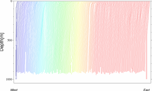
| ◊Station map | ◊Vertical temperature profile Vertical profile of temperature along the observing line of PX40 moved the entire profile by 5 degree Celsius. |
 |
 |
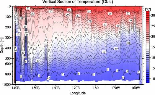
| ◊Vertical observation sections | ◊Summary of differences (Obs. - Assim.) by depth Dots and error bars represent the averages and root mean squares of the differences, respectively. Crosses represent the maximum/minimum differences. |
 |
 |
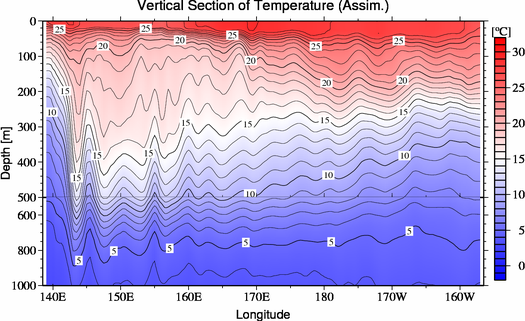
| ◊Vertical sections for the result of assimilation by MOVE-NP | ◊Distribution of differences (Obs. - Assim.) by depth |
 |
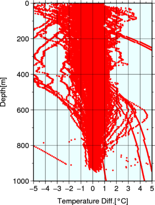 |
| ◊Vertical sections of differences (Obs. - Assim.) | ◊Distribution of differences (Obs. - Assim.) by temperature |
 |
 |