MTSAT-1R Infrared Inter-calibration with High-spectral-resolution Sounders
The Meteorological Satellite Center examines inter-calibration between MTSAT infrared channels and high-spectral-resolution sounders (hyper sounders). This study uses data from two hyper sounders.
- The Atmospheric Infrared Sounder (AIRS) is a multi-aperture array grating spectrometer on the AQUA satellite launched by the National Aeronautics and Space Administration (NASA, U.S.).
- The Infrared Atmospheric Sounding Interferometer (IASI) is installed on the Metop-A satellite launched by the European Organization for the Exploitation of Meteorological Satellites (EUMETSAT, EU).
Inter-calibration is conducted once a day. The hyper-sounder data used in this study are collected via the Internet. In the event of poor network conditions, inter-calibration computation may be canceled.
Outcome
The results of this inter-calibration study have three statistical parameters. Please note that the results contain some inaccuracies arising from observation errors in MTSAT and the hyper sounders, differences in observation conditions and spectral compensation residuals.
-
Regression coefficients between the radiances of hyper sounders and MTSAT
Linear regression coefficients (C0 and C1) and their standard uncertainties are computed to allow association of the MTSAT radiance with hyper sounder radiance. The radiance is in wavenumber space, and its unit is mW.m-2.sr-1.cm.
Radiance (MTSAT) = C0 + C1 × Radiance (hyper sounder)
-
TB difference between hyper sounder and MTSAT
The brightness temperature (Tb) difference (MTSAT value minus hyper sounder value) and its standard uncertainties associated with MTSAT and hyper sounder radiance regression are computed at reference temperatures of 290 K, 250 K and 220 K.
d Tb = Tb (MTSAT) − Tb (hyper sounder)
Conversion between brightness temperature and radiance
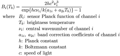
To compute brightness temperature from radiance, the Planck function and sensor spectral response functions are used. In general, approximation equations called sensor Planck functions, which are generated for the MTSAT infrared channels, are used to facilitate the computation.
| MTSAT-1R channel |
Wavenumber | Band correction coef. | |
|---|---|---|---|
| ν (cm-1) | a1 | a2 | |
| IR1 (10.8 μm) | 926.6118 | 0.3592380 | 0.9987587 |
| IR2 (12.0 μm) | 833.1675 | 0.1968675 | 0.9992525 |
| IR3 (6.8 μm) | 1482.2068 | 0.3785336 | 0.9991187 |
| IR4 (3.8 μm) | 2652.9316 | 2.3473427 | 0.9969755 |
Algorithm
To compare data between MTSAT and hyper sounders, the information simultaneously observed is first collocated. Then, the radiances observed by hyper sounder channels are accumulated according to the spectral responses of the MTSAT infrared channels to estimate MTSAT radiances.
The footprint size of the hyper sounders is about 12 km at nadir, whereas that of the MTSAT infrared channels is 4 km. To offset this difference, sounder radiance is compared with an average value for MTSAT radiances over a box of 3 × 3 pixels (FOV_BOX) corresponding to the sounder footprint.
The collocation and spectral compensation methods are briefly described below. The details are published in the Meteorological Satellite Center Technical Note in 2009.
Collocation Method
Collocation algorithms used in inter-calibration are determined by the GSICS research working group (GSICS, 2007). MTSAT and hyper sounder data are selected if they meet the criteria outlined below.
-
Observation time difference check
| tmtsat − tsounder | < dtmax
-
Satellite zenith angle difference check
| cos( SZAsounder ) / cos( SZAmtsat ) − 1 | < MaxRate_OptPathDiff
-
Environment uniformity check
To mitigate differences between the observation conditions of the two satellites due to time difference, optical path difference, navigation error, etc., only measurements over uniform scenes are selected and compared. In this check, the uniformity of MTSAT radiance data over a box of 9 × 9 pixels (ENV_BOX) is tested usingSTDV(MTSAT radiances in ENV_BOX) < MaxSTDV .
-
Normality check
Sounder radiance is compared to the average MTSAT radiance over the corresponding FOV_BOX. The MTSAT radiance data in the FOV_BOX should therefore represent the data in the ENV_BOX evaluated by the environment uniformity check. The normality of the MTSAT radiance data in the FOV_BOX is check using| MEAN(FOV_BOX) − MEAN(ENV_BOX) | × 9 / STDV(ENV_BOX) < Gaussian .
The table below shows the criteria used in inter-calibration between MTSAT-1R and AIRS/IASI. The variables differ according to weather conditions. In this study, if the brightness temperature of IR1 (10.8 μm) is higher than 275 K, the scene condition is categorized as clear. Otherwise, it is categorized as cloudy.
| MTSAT-1R channel |
Condition |
dtmax (minutes) |
MaxRate OptPathDiff |
MaxSTDV (mW.m-2.sr-1.cm) |
Gaussian |
|---|---|---|---|---|---|
| IR1 (10.8 μm) |
Clear | 5 | 0.01 | 1.65 | 2 |
| Cloudy | 5 | 0.03 | 3.31 | 2 | |
| IR2 (12.0 μm) |
Clear | 5 | 0.01 | 1.82 | 2 |
| Cloudy | 5 | 0.03 | 3.64 | 2 | |
| IR3 (6.8 μm) |
All | 5 | 0.01 | 0.311 | 1 |
| IR4 (3.8 μm) |
Clear | 5 | 0.01 | 0.0151 | 2 |
| Cloudy | 5 | 0.03 | 0.0302 | 2 |
Spectral Response Compensation Method
The collocated MTSAT and hyper sounder data cannot be compared without considering the sensors' spectral response difference. In this study, the average MTSAT radiance over the FOV_BOX is compared with the super channel radiance Isuper, which is generated by accumulating the hyper sounder radiances Ijsounder.
i: MTSAT channel number
j: hyper sounder channel number
wij are constants that are computed in advance to exactly fit the spectral response of the super channel to that of the MTSAT infrared channel i.
If the spectral range of the hyper sounder does not fully cover the MTSAT spectral range and/or some hyper sounder channel measurements are missing, spectral compensation is applied to the super channel radiance.
This is performed by evaluating the valid radiance measurements of the hyper sounder and radiances simulated beforehand for eight model profiles including clear and cloudy conditions.
For more details regarding the super channel and the spectral compensation methods, please refer to Tahara (2008) and Tahara and Kato (2009).
Reference
- GSICS, 2007: GSICS co-location algorithm for GEO Imagers and AIRS, Unpublished
- Tahara, Yoshihiko, 2008: New Approach to Inter-calibration Using High Spectral Resolution Sounder, Meteorological Satellite Center Technical Note, No. 50, 1-14. (PDF, 746 KB)
- Tahara, Yoshihiko and Koji Kato, 2009: New Spectral Compensation Method for Inter-calibration Using High Spectral Resolution Sounder, Meteorological Satellite Center Technical Note, No. 52, 1-37. (PDF, 5.91 MB)
- WMO, 2006: Implementation Plan for a Global Space-Based Inter-Calibration System (GSICS), version 1, April 2006. World Meteorological Organization, 22 pp.