World Weather Watch
In order to improve weather forecasting, the World Meteorological Organization (WMO) promotes the World Weather Watch (WWW) program that modernizes the meteorological services of the National Meteorological and Hydrological Services (NMHSs) by utilizing the latest results of science and technology under the cooperation of the WMO member countries. The main purpose of the WWW program is to observe weather around the world uniformly. Meteorological satellites that have a capability to observe a wide range of the earth from space are exactly suitable for this role.
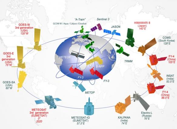
The combination of geostationary and polar orbiting meteorological satellites is one of the most important parts of the Global Observation System of the WWW program.
Himawari-8/9 takes an indispensable part of the Global Observing System as shown in the above figure and makes a great contribution to the meteorological services of not only Japan but also the world.
Current operational Geostationary Meteorological Satellites
| Sector | Long | Name | Operator(s) |
|---|---|---|---|
| West-Pacific (108E-180E) |
112E | FY-2F | CMA, NRSCC |
| 123.5E | FY-4B | ||
| 128.2E | GEO-KOMPSAT-2A | KMA, KARI, ME, MLTM | |
| 128.2E | GEO-KOMPSAT-2B | ||
| 140.7E | Himawari-8 | JMA (MSC) | |
| 140.7E | Himawari-9 | ||
| East-Pacific (180W-108W) |
128W | GOES-15 | NOAA, NASA |
| West-Atlantic (108W-36W) |
105W | GOES-14 | NOAA, NASA |
| 137.2W | GOES-17 | ||
| 89.5W | GOES-18 | ||
| 75.2W | GOES-16 | ||
| East-Atlantic (36W-36E) |
14.5W | Electro-L N2 | RosHydroMet, Roscosmos |
| 0 | Meteosat-11 | EUMETSAT, ESA | |
| 9.5E | Meteosat-10 | ||
| Indian Ocean (36E-108E) |
41.5E | Meteosat-8(IODC) | EUMETSAT, ESA |
| 74E | INSAT-3DR | ISRO, IMD | |
| 76E | Electro-L N3 | RosHydroMet, Roscosmos | |
| 79E | FY-2H | CMA, NRSCC | |
| 82E | INSAT-3D | ISRO, IMD | |
| 99.5E | FY-2G | CMA, NRSCC | |
| 104.7E | FY-4A |
Current Sun-synchronous Meteorological Satellites
| Name | Altitude | Operator |
|---|---|---|
| DMSP-F17 | 848km | DoD, NOAA |
| DMSP-F18 | 850 km | |
| NOAA-15 | 813 km | NOAA |
| NOAA-18 | 854 km | |
| NOAA-19 | 870 km | |
| NOAA-20 | 834 km | NOAA, NASA |
| SNPP | 833 km | |
| Meteor-M N2 | 820 km | RosHydroMet, Roscosmos |
| Meteor-M N2-2 | 821 km | |
| Metop-B | 827 km | EUMETSAT, ESA |
| Metop-C | 817 km | |
| FY-3C | 836 km | CMA, NRSCC |
| FY-3D | 836 km | |
| FY-3E | 836 km |