Abstract
In December 2005, it was extremely cold over northeastern Asia, and monthly mean temperature of Japan was the lowest since 1948. It was found from JMA's examinations that the extremely active cumulus convection over the Bay of Bengal, the South China Sea and the Philippine Sea was deeply related to the cold weather, besides the influence of the persistency of the negative phase of the Arctic Oscillation (AO). The stationary Rossby wave train along the strong Asian Jet, which was excited by the active cumulus convection over those areas, caused the persistent and large-amplitude meandering of the jet, leading to the repetitive cold air outbreaks in and around Japan.
1. Introduction
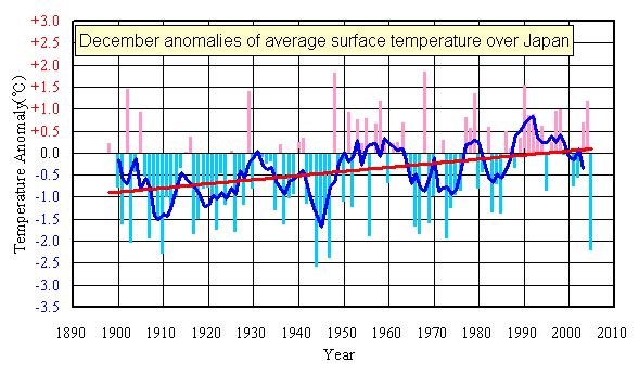
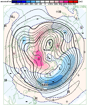
Monthly mean temperatures were significantly below normal in northeastern Asia, including Mongolia, northern China, Korea and Japan. According to the observation data averaged at 17 points in Japan which were used for monitoring the global warming, monthly mean temperature for the whole Japan was the fourth lowest since 1898, next to 1944, 1947 and 1910 (Figure 1). Additionally, significantly heavy snow fell broadly in the Japan Sea side of Japan, and the records of maximum snow depth in December were set at 106 meteorological observatories out of 339, including automated stations, of JMA. At 500-hPa height field, it was observed that positive and negative anomalies in the Arctic area and the middle latitudes in the Northern Hemisphere, respectively: the predominantly negative phase of the AO persisted through the month (Figure 2 and Figure 3). It is well known that the behavior of the AO, which is considered a phenomenon explained by internal dynamics of the extra-tropical atmosphere and inevitably involving chaotic nature, is related to the strength of the East Asian winter monsoon. Meanwhile, in the tropics, extremely stronger-than-normal convective activities across the Bay of Bengal to the Philippine Sea were observed (Figure 4). This active convection also made an influence on the cold weather in and around Japan. In this report, the mechanism of the influence of the active convection on the East Asian winter monsoon is examined with diagnostic analyses.
2. Diagnosis
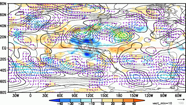
In December 2005, convective activities, inferred from Outgoing Longwave Radiation (OLR) fluxes, were much stronger than normal over the Bay of Bengal, the South China Sea and the Philippine Sea, as shown in Figure 4. The anomalies of the active convection were about triple of its standard deviations and the largest for the December since 1979. In the upper troposphere north of the active convection areas, there was an anti-cyclonic circulation anomaly, followed by cyclonic and anti-cyclonic ones centered east off Japan and over the mid-Pacific, respectively. The set of the anomalies seems to form a stationary Rossby wave train. Wave activity fluxes (Takaya and Nakamura, 2001) clearly show that the wave energy propagated eastward from the anti-cyclonic circulation anomaly north of the active convection areas to the Pacific, supporting this hypothesis. This stationary Rossby wave train caused the large-scale southward shift of the jet over Japan, which brought the extremely cold weather in and around Japan.
The exciting mechanism of this stationary Rossby wave is thought to be as follows. Active convection generates large-scale latent heat release in the middle troposphere. The atmospheric warming causes above-normal divergence in the upper troposphere, resulting in stronger-than-normal divergent winds. The anomalous divergence contributes to generating the anti-cyclonic circulation anomaly in the upper troposphere, which acts as a Rossby wave source. Then the energy of the stationary Rossby wave propagates downstream along the jet, which works as a wave guide.
The mechanism of the influence of the active convection across the Bay of Bengal to the Philippine Sea on the cold weather in and around Japan was supported by the results of the numerical simulation conducted (Watanabe, 2006). The simulation is a examination of the linear steady response to hypothetical heating anomalies over those areas by using a linearized Global Circulation Model (Watanabe and Kimoto, 2000) around three-dimension climatological circulation fields in December. The results show that simulated circulation anomalies in the upper and lower troposphere are quite similar to those observed (not shown).
3. Discussion
It is clearly shown that the extremely anomalous heating generated by predominantly active convection over the Bay of Bengal, the South China Sea and the Philippine Sea excited the stationary Rossby wave train trapped in the Asian jet over East Asia and the North Pacific, leading to the repetitive cold air outbreaks in and around Japan. However, it remains to answer why such anomalous convection persisted over the regions in December 2005.
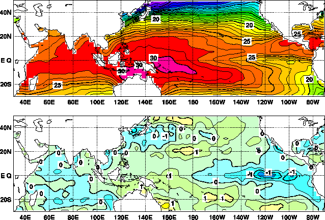
One of the possible reasons is the influence of the tropical Sea Surface Temperature (SST) anomaly. In December 2005, the pattern of SST anomaly is similar to that observed during La Nina events, that is, above- and below-normal in the western and eastern Pacific, respectively, as shown in Figure 5. Moreover, SSTs were above-normal over the Bay of Bengal. These situations are considered favorable for more active convection across the Bay of Bengal to the Philippine Sea. So, it is possible that a positive feedback mechanism between the atmosphere and ocean in the tropics helped to maintain the active convection over the areas. A simulation experiment with a fully coupled ocean-atmosphere model might be necessary to verify the above hypothesis.
Another possible reason is the interaction between the tropics and extra-tropics. It is known that the convection over the South China Sea is enhanced after a strong surge of winter monsoon over East Asia. Actually, it was observed that convection over the South China Sea was enhanced at some occasions after a cold surge in East Asia in December 2005. Considering this fact and the result of the numerical simulation (Watanabe, 2006), it is implied that a positive feedback mechanism works between the tropical convection and Asian winter monsoon surges. It is necessary that the possible feedback mechanism be confirmed by further investigations.
4. Conclusion
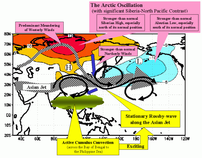
From the diagnostic analyses and numerical simulation, it was found that, besides the influence of the persistency of the negative phase of the AO, extremely active cumulus convection over the Bay of Bengal, the South China Sea and the Philippine Sea was deeply related to the extremely cold weather in and around Japan in December 2005. It can be explained that the teleconnection phenomenon, possibly called "Southeast Asia-East Asia-the North Pacific teleconnection pattern", took place and led to the cold weather over Japan in December. The striking atmospheric circulation related to the cold weather is drawn as a schematic diagram in Figure 6.
But it still remains to reveal the reason for the persistency of the active convection over the areas. Accordingly, we should further investigate to reveal the maintenance mechanisms of the active convection and to understand quantitatively to what extent each of the causes derived from AO and the active convection contributed to the cold weather. Furthermore, it is necessary to examine whether the AO interacts with the stationary Rossby wave excited by the active tropical convection.
Acknowledgements
We deeply appreciate Dr. Masahiro Watanabe at Hokkaido University for permitting us to use his latest result of linearized model simulation.
References
Takaya, K., and H. Nakamura, 2001: A formation of a phase-independent wave-activity flux of stationary and migratory quasi-geostrophic eddies on a zonally-varying basic flow, J. Atmos. Sci., 58, 608-627.
Watanabe, M., and M. Kimoto, 2000: Atmospheric-ocean thermal coupling in the North Atlantic: A positive feedback. Quart. J. R. Met. Soc., 126, 3343-3369.
Watanabe, M., 2006: personal communication
(Shuhei Maeda, Climate Prediction Division)
 |
 |
| Home | About Us | Topics | Data and Products | Long-Range Forecast | Library | Site Map | Related Links | Copyright & Disclaimer |