Product Explanation
Types
With reference to information on volcanic eruptions/ash in the atmosphere and related monitoring, the Tokyo VAAC issues up-to-date information on ash observation and forecast movement as detailed below.
-
VAA information
VAA information is issued in abbreviated plain language and IWXXM GML format, with details including volcanic ash presence, extent and forecast movement (6-, 12- and 18-hour forecasts).
-
VAA Information in Graphical Format (VAG)
VAG information details volcanic ash presence, extent and forecast movement (6-, 12- and 18-hour forecasts).
-
Volcanic Ash Graphic for Initial Distribution (VAGI)
VAGI information details the extent of volcanic ash.
-
Volcanic Ash Graphic Forecast for Narrow Area (VAGFN)
VAGFN information details the forecast movement of volcanic ash by altitude when a volcano erupts (hourly forecasts for the coming six hours).
-
Volcanic Ash Graphic Forecast for Narrow Area of Hypothetical Routine Eruption and Ash Fall (VAGFNR-AF)
VAGFNR-AF information details the forecast movement of volcanic ash and ash fall by altitude with the assumption of eruption of a domestic volcano with increased potential for eruption (hourly forecasts for the coming three hours).
Based on ICAO recommendations, 1 and 2 are issued by the Tokyo VAAC, while 3, 4 and 5 are issued in line with user demand.
Issuance criteria
The criteria, timing and frequency of issuance for the various types of information are as detailed below.
-
Information issued when an eruption occurs or volcanic ash is detected
-
Ash detection by a meteorological satellite
VAA, VAG, VAGI and VAGFN information is issued.
Information is updated as necessary if new observation data regarding eruptions or ash are obtained while atmospheric ash is present.
Updates are made at intervals of six hours or less even if no new observation data are obtained.
When volcanic ash is not detected by a meteorological satellite, information to that effect is issued.
-
No ash detection by a meteorological satellite
VAA information is issued when the Tokyo VAAC obtains observation data on eruptions and volcanic ash.
Once an eruption is observed by a meteorological watch office or a volcano observatory, and the height of the ash plume is determined, VAGFN information is also issued.
-
Regular issuance regardless of volcanic ash status
- VAGFNR-AF information is issued at three-hour intervals (00, 03, 06, 09, 12, 15, 18 and 21 UTC).
Information details
1. VAA information
VAA content is as detailed below.
| Content | Details |
| FVFE01 RJTD DDhhmm | VAA data type code, issuance office, issuance time |
| VA ADVISORY | Type of message |
| STATUS | Indicator of test or exercise (inclusion conditional, included whenever applicable) |
| DTG | Time of origin |
| VAAC | Name of VAAC |
| VOLCANO | Name and number of volcano |
| PSN | Location of volcano in degrees and minutes |
| AREA | State, or region if ash is not reported over a State |
| SOURCE ELEV | Source elevation in m (or ft) AMSL (or BLW MSL) |
| ADVISORY NR | Advisory number; year in full and message number (separate sequence for each volcano) |
| INFO SOURCE | Information sources |
| ERUPTION DETAILS | Eruption details including date/time of eruption(s) |
| OBS VA DTG | Day and time of observation of volcanic ash |
| OBS VA CLD | Horizontal (in degrees and minutes) and vertical extent and movement at the time of observation of the observed ash cloud or, if the base is unknown, the top of the observed or estimated ash cloud. |
| FCST VA CLD | Forecast height and position (in degrees and minutes) for each cloud mass for that fixed valid time (approximately 6, 12 and 18 hours from the time of observation of ash given in OBS VA DTG) |
| RMK | Remarks as necessary |
| NXT ADVISORY | Next advisory (scheduled time) |
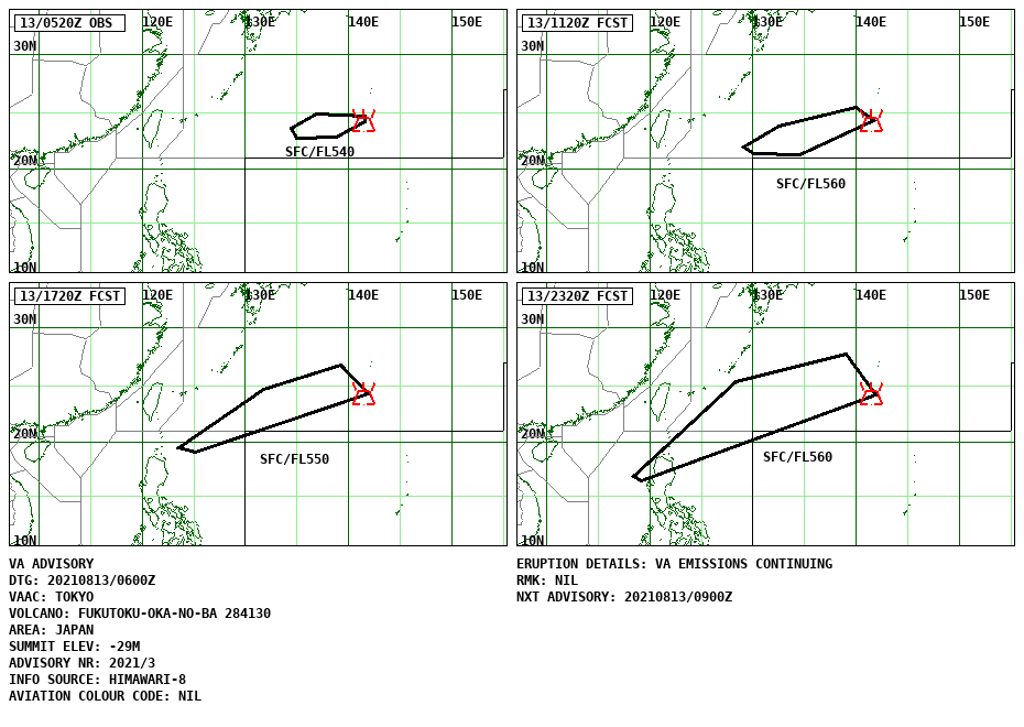
Example of VAA information
FVFE01 RJTD 130600
VA ADVISORY
DTG: 20210813/0600Z
VAAC: TOKYO
VOLCANO: FUKUTOKU-OKA-NO-BA 284130
PSN: N2417 E14129
AREA: JAPAN
SOURCE ELEV: 29M BLW MSL
ADVISORY NR: 2021/3
INFO SOURCE: HIMAWARI-8
ERUPTION DETAILS: VA EMISSIONS CONTINUING
OBS VA DTG: 13/0520Z
OBS VA CLD: SFC/FL540 N2413 E14136 - N2251 E13850 - N2243 E13455 -
N2336 E13423 - N2455 E13655 - N2442 E14134 MOV W 50KT
FCST VA CLD +6 HR: 13/1120Z SFC/FL560 N2420 E14141 - N2116 E13432 -
N2121 E13006 - N2157 E12908 - N2348 E13229 - N2529 E13959
FCST VA CLD +12 HR: 13/1720Z SFC/FL550 N2415 E14153 - N1904 E12509 -
N1926 E12334 - N2441 E13143 - N2646 E13913
FCST VA CLD +18 HR: 13/2320Z SFC/FL560 N2413 E14153 - N1623 E11912 -
N1648 E11823 - N2520 E12821 - N2745 E13859
RMK: NIL
NXT ADVISORY: 20210813/0900Z=
2. VAG
Example of VAG is shown below.
In addition to the details of VAAs, VAG information includes observation and forecasting for the periods 6, 12 and 18 hours ahead.
However, if volcanic ash is expected to dissipate, "NO VA EXP" will be displayed.
The observation or forecast time is shown in the upper left of each figure, and the area of observed or forecast ash movement is indicated by polygons surrounded by a solid or dotted line.
Alphanumeric characters beside polygons indicate the minimum and maximum heights of volcanic ash.
The location of the relevant volcano is indicated as a symbol in this figure.
Example of VAG
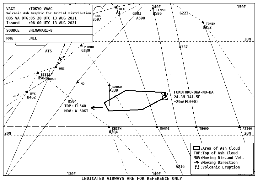
3. VAGI
Example of VAGI is shown below.
VAGI information details the current situation of volcanic ash in the atmosphere.
In the figure, the name of the issuing organization (TOKYO VAAC), the ash observation time (OBS VA DTG), the issuance time (Issued), the information source (SOURCE) and remarks (RMK) are shown.
The black line shows the range of volcanic ash observed by meteorological satellites.
Ash movement, the name of the volcano, the location (latitude/longitude), the altitude and the air route are shown for reference.
Example of VAGI
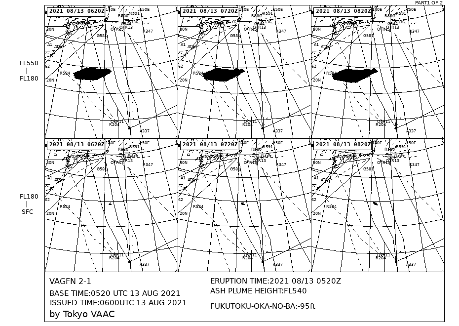
4. VAGFN
Example of VAGFN is shown below.
VAGFN information shows hourly forecast movement of volcanic ash.
The product features 1-3-hour forecasts on the first page and 4-6-hour forecasts on the second page with black fill.
The upper part of the figures shows the forecast for the FL180- FL550 altitude range, and the lower part shows that for SFC (ground surface)-FL180.
The content also includes the initial time (BASE TIME), the origin time (ISSUED TIME), the issuing organization (Tokyo VAAC), the volcano name and altitude, the eruption time or volcanic ash observation time (ERUPTION TIME) and the volcanic ash height (ASH PLUME HEIGHT).
Example of VAGFN
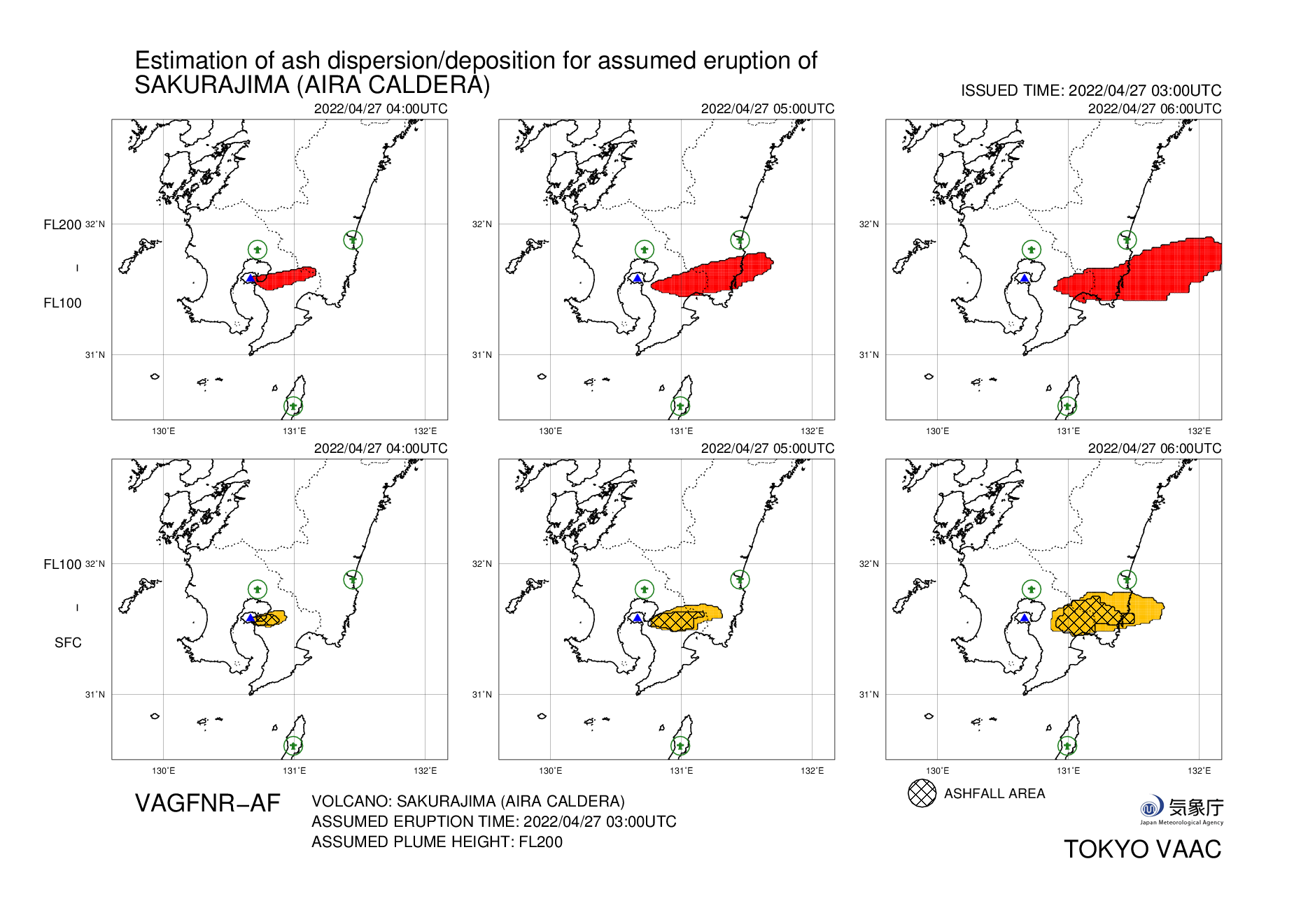
5. VAGFNR-AF
Example of VAGFNR-AF is shown below.
VAGFNR-AF information shows forecast movement of volcanic ash for every hour and the prediction range of ash fall up to three hours ahead with the assumption of a single eruption for domestic volcanoes with high potential for eruption.
The figure in the attachment consists of an upper row showing forecast movement of volcanic ash in the FL100-FL200 altitude range with red fill and a lower row showing forecast movement in the SFC- FL100 altitude range with orange fill, along with the predicted range of ash fall with shading.
The content also includes the issuance time (ISSUED TIME), the volcano name (VOLCANO), the assumed eruption time (ASSUMED ERUPTION TIME) and assumed plume height (ASSUMED PLUME HEIGHT), a symbol indicating the location of the volcano and a symbol indicating the location of the airport.
Example of VAGFNR-AF
VAG, VAGI, VAGFN and VAGFNR-AF information was created using GSHHG (Global Self-consistent Hierarchical High-resolution Geography; Wessel, P., and W. H. F. Smith,
A Global Self-consistent, Hierarchical, High-resolution Shoreline Database, J. Geophys. Res., 101, #B4, pp. 8741-8743, 1996).
|