Composite analysis of atmospheric circulation in El Niño / La Niña and Indian Ocean Dipole events
This page outlines statistical analysis of atmospheric circulation and related characteristics associated with the El Niño-Southern Oscillation (ENSO) and Indian Ocean Dipole (IOD).
|
|
Data and methods
Sea surface temperatures (SSTs) are based on COBE-SST2 datasets (Hirahara et al. 2014; https://www.data.jma.go.jp/tcc/tcc/products/elnino/cobesst2_doc.html) before May 2015 and MGDSST (Merged satellite and in-situ data Global Daily SST) datasets after June 2015.
Atmospheric circulation data are based on JRA-3Q (Kosaka et al. 2024; https://jra.kishou.go.jp/JRA-3Q/index_en.html),
and tropical convective activity is inferred from outgoing longwave radiation (OLR).
The original OLR data are from observations conducted by NOAA's polar-orbiting satellites.
High-frequency variations such as eddy kinetic energy are defined as two- to eight-day band-pass filtered fields.
Monthly and three-month mean fields are calculated from these datasets.
The base period for the analysis is 1948 - 2021 (1979 - 2021) for SST and JRA-3Q (OLR) datasets, while that for the three-month periods from November to January and December to February is 1947/48 - 2020/21 (1979/80 - 2020/21).
Anomalies are defined as deviations from the average in these 74-year (43-year for OLR) periods.
It has been suggested that atmospheric response to tropical SST anomalies during El Niño events does not always correspond to that observed during La Niña events (Hoerling et al. 2001).
Composite analysis of anomaly fields has been performed in consideration of the asymmetric relationship between these events.
As for IOD composites, positive (negative) IOD events in concurrence with El Niño (La Niña) events were excluded in related statistical surveying for extraction of pure IOD impacts on the climate.
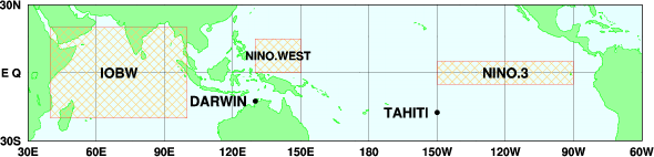
The El Niño Monitoring Indices used in analysis and for the corresponding regions are shown in Table.1.
In the definition of El Niño and La Niña phases, the five-month running mean SST deviation in NINO.3, NINO.WEST and IOBW satisfies the threshold requirements shown in Table.1 for at least six consecutive months.
The definition for NINO.3 is based on that used by JMA.
The SST deviation is defined as the deviation from the latest sliding 30-year period.
Please see also the Download El Niño Monitoring Indices page.
Table 1 El Niño Monitoring Indices
| ENSO Index |
Area |
ENSO threshold (five-month running mean) |
| La Niña phase |
El Niño phase |
| NINO.3 |
Eastern Pacific |
5ºS - 5ºN, 150ºW - 90ºW |
Below -0.5ºC |
Above +0.5ºC |
| NINO.WEST |
Western Pacific |
EQ - 15ºN, 130ºE - 150ºE |
Above +0.15ºC |
Below -0.15ºC |
| IOBW |
Indian Ocean Basin |
20ºS - 20ºN, 40ºE - 100ºE |
Below -0.15ºC |
Above +0.15ºC |
The IOD Monitoring Indices used in this analysis and for the corresponding regions are shown in Table 2.
The configuration for IOD-related regions is as per Saji et al (1999).
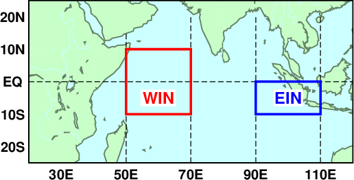
IOD events are identified with the Dipole Mode Index (DMI).
The DMI is based on differences in area-averaged monthly-mean SST deviations between the tropical western Indian Ocean [50 - 70ºE, 10ºS - 10ºN] (denoted as WIN) and the southeastern tropical Indian Ocean [90 - 110ºE, 10ºS - Equator] (denoted as EIN), with monthly-mean SST deviation based on linear extrapolation with respect to the latest sliding 30-year mean for each calendar month. Positive and negative IOD events generally both occur in boreal summer and autumn (from June through November). Positive (negative) IOD events are identified when the three-month running mean DMI is +0.4ºC or above (-0.4ºC or below) for at least three consecutive months between June and November.
Please see also the Download Indian Ocean Dipole Monitoring Indices page.
Table 2 Indian Ocean Dipole Monitoring Indices
| IOD Index |
Area |
| WIN |
Western Indian Ocean |
10ºS - 10ºN, 50ºE - 70ºE |
| EIN |
Eastern Indian Ocean |
10ºS - EQ, 90ºE - 110ºE |
| DMI |
- |
Difference between WIN and EIN |
Statistical characteristics
This section outlines the characteristics of seasonal mean composite anomalies in the positive and negative phases of the ENSO indices.
1. Atmospheric circulation in the El Niño (positive) phase of NINO.3
Winter (December - February)
OLR and precipitation anomalies indicate that convective activity is enhanced over the central to eastern equatorial Pacific and suppressed over and around the Maritime Continent in response to the east-west contrast of SST anomalies over the equatorial Pacific.
Suppressed convective activity is seen over the South Pacific Convergence Zone (SPCZ), the northern part of South America and the tropical North Atlantic.
The Inter-Tropical Convergence Zone (ITCZ) exhibits equatorward shift.
In the lower troposphere, cyclonic (anti-cyclonic) circulation anomalies straddling the equator are seen over western to central parts of the Pacific (the eastern Indian Ocean to the Maritime Continent), accompanied with equatorial westerly (easterly) wind anomalies.
These patterns are consistent with those of the "Matsuno - Gill" response (Matsuno 1966, Gill 1980) to convective heat source anomalies.
In the upper troposphere, the signs of anomaly patterns are opposite to those observed in the lower troposphere.
Zonal wind anomalies in the lower and upper troposphere indicate weaker-than-normal Walker Circulation.
The subtropical jet stream demonstrates a southward shift over the area from the Middle East to East Asia in line with cyclonic circulation anomalies in the upper troposphere. The jet stream exhibits northward meandering from Japan to the seas east of Japan.
The jet stream exhibits northward meandering to the east of Japan.
In the 500-hPa height field, wave trains such as the Pacific - North American (PNA) pattern (Wallace and Gutzler 1981) are seen over the area from the tropical North Pacific to North America with negative anomalies to the south of Alaska.
In line with these anomalies, negative sea-level pressure anomalies are seen to the south of Alaska, indicating enhancement and eastward shifting of the Aleutian Low.
Spring (March - May)
OLR and precipitation anomalies indicate that convective activity is enhanced over the central to eastern equatorial Pacific and suppressed over and around the Maritime Continent in response to the east-west contrast of SST anomalies over the equatorial Pacific.
Suppressed convective activity is seen over the equatorial Atlantic and the North Indian Ocean.
In the lower troposphere, cyclonic (anti-cyclonic) circulation anomalies straddling the equator are seen over the equatorial Pacific (from the Indian Ocean to the Maritime Continent), accompanied with equatorial westerly (easterly) wind anomalies.
In the upper troposphere, the signs of anomaly patterns are opposite to those observed in the lower troposphere, indicating weaker-than-normal Walker Circulation.
The subtropical jet stream exhibits a southward shift over the area from the Middle East to southern China and a northward shift to the east of Japan.
In the 500-hPa height field, positive anomalies are seen over Japan in line with the northward meandering of the jet stream.
Summer (June - August)
OLR and precipitation anomalies indicate that convective activity is enhanced over the equatorial Pacific and suppressed over the Maritime Continent in response to the east-west contrast of SST anomalies over the equatorial Pacific.
Suppressed convective activity is seen over India, indicating an inactive Indian monsoon.
The coefficient of correlation between the NINO.3 index and the intensity of the Asian summer monsoon (SAMOI-A) is a statistically significant negative value, indicating the weaker-than-normal Asian monsoon circulation seen in El Niño events (not shown).
In the lower troposphere, cyclonic circulation anomalies straddling the equator are seen over the Pacific, accompanied with equatorial westerly wind anomalies.
However, these composite maps for boreal summer are likely to capture different characteristics during both developing and decaying stages of El Niño events.
In post-El Niño boreal summers, with the sign reversed to the composite maps described above, northeasterly or easterly wind anomalies are seen in and around the southern part of the South China Sea, and anti-cyclonic circulation anomalies are seen over the Philippines (figure not shown).
This is consistent with those of Indian Ocean capacitor effect proposed by Xie et al. (2009).
In the upper troposphere, the signs of anomaly patterns are opposite to those observed in the lower troposphere.
Cyclonic circulation anomalies are seen over vast areas of southern Eurasia, indicating a weaker-than-normal Tibetan High in its northern part and a southward shift of the subtropical jet stream.
In the 500-hPa height field, negative anomalies are seen over Japan and the North Pacific in line with southward meandering and enhancement of the jet stream over Japan and the North Pacific, respectively.
In the sea level pressure and 850-hPa stream function fields, negative anomalies are seen over vast areas of the North Pacific, indicating a weaker-than-normal subtropical high.
Autumn (September - November)
OLR and precipitation anomalies indicate that convective activity is enhanced over the equatorial Pacific and suppressed over and around the Maritime Continent in response to the east-west contrast of SST anomalies over the equatorial Pacific.
In the lower troposphere, cyclonic (anti-cyclonic) circulation anomalies straddling the equator are seen over the western to central Pacific (the Indian Ocean), accompanied with equatorial westerly (easterly) wind anomalies.
In the upper troposphere, the signs of anomaly patterns are opposite to those observed in the lower troposphere, indicating weaker-than-normal Walker Circulation.
The subtropical jet stream exhibits a southward shift over vast areas from Northern Africa to the North Pacific in line with cyclonic circulation anomalies in the upper troposphere.
2. Atmospheric circulation in the La Niña (negative) phase of NINO.3
Winter (December - February)
OLR and precipitation anomalies indicate that convective activity is suppressed over the western to central equatorial Pacific and enhanced over and around the Maritime Continent in response to the east-west contrast of SST anomalies in the equatorial Pacific.
Enhanced convective activity is seen over the South Pacific Convergence Zone (SPCZ) and the northern part of South America.
In the lower troposphere, anti-cyclonic (cyclonic) circulation anomalies straddling the equator are seen over the western to central Pacific (from the eastern Indian Ocean to the Maritime Continent), accompanied with equatorial easterly (westerly) wind anomalies.
In the upper troposphere, the signs of anomaly patterns are opposite to those observed in the lower troposphere.
Zonal wind anomalies in the lower and upper troposphere indicate stronger-than-normal Walker Circulation.
The subtropical jet stream exhibits a northward shift over East Asia in line with anti-cyclonic circulation anomalies in the upper troposphere.
The jet stream is stronger than normal over Japan.
In the 500-hPa height field, wave trains associated with the PNA pattern are seen over the area from the tropical North Pacific to North America with positive anomalies to the south of Alaska.
In line with the positive anomalies, positive sea-level pressure anomalies are seen to the south of Alaska, indicating that the Aleutian Low is generally weaker than normal except to the northeast of Japan with negative sea-level pressure anomalies.
Spring (March - May)
OLR and precipitation anomalies indicate that convective activity is suppressed over the equatorial Pacific and enhanced over and around the Maritime Continent in response to the east-west contrast of SST anomalies.
Enhanced convective activity is seen over the equatorial Atlantic and the North Indian Ocean.
In the lower troposphere, anti-cyclonic (cyclonic) circulation anomalies straddling the equator are seen over the equatorial Pacific (from the Indian Ocean to the Maritime Continent), accompanied with equatorial easterly (westerly) wind anomalies.
In the upper troposphere, the signs of anomaly patterns are opposite to those observed in the lower troposphere, indicating stronger-than-normal Walker Circulation.
The subtropical jet stream exhibits a northward shift over South to East Asia.
Summer (June - August)
OLR and precipitation anomalies indicate that convective activity is suppressed over the equatorial Pacific and enhanced over the Maritime Continent in response to the east-west contrast of SST anomalies.
Enhanced convective activity is seen near India, indicating an active Indian monsoon.
The statistical relationship between NINO.3 and SAMOI-A indicates the stronger-than-normal Asian monsoon circulation seen in La Niña events (not shown).
In the lower troposphere, anti-cyclonic circulation anomalies straddling the equator are seen over the Pacific, accompanied with equatorial easterly wind anomalies.
In the upper troposphere, the signs of anomaly patterns are opposite to those observed in the lower troposphere.
Anti-cyclonic circulation anomalies are seen over Eurasia, especially over northeastern Middle East and the northeastern part of East Asia, indicating a stronger-than-normal Tibetan High in its northern part and a northward shift of the subtropical jet stream.
In the 500-hPa height field, positive anomalies are seen over Japan in line with northward meandering of the jet stream.
In the sea level pressure and 850-hPa stream function fields, positive anomalies are seen over vast areas of the North Pacific, indicating a stronger-than-normal subtropical high.
Autumn (September - November)
OLR and precipitation anomalies indicate that convective activity is suppressed over the equatorial Pacific and enhanced over and around the Maritime Continent in response to the east-west contrast of SST anomalies over the equatorial Pacific.
In the lower troposphere, anti-cyclonic (cyclonic) circulation anomalies straddling the equator are seen over the western to central Pacific (the Indian Ocean), accompanied with equatorial westerly (easterly) wind anomalies.
In the upper troposphere, the signs of anomaly patterns are opposite to those observed in the lower troposphere, indicating stronger-than-normal Walker Circulation.
The subtropical jet stream exhibits a northward shift over vast areas of southern Eurasia in line with anti-cyclonic circulation anomalies in the upper troposphere.
3. Atmospheric circulation in the El Niño (negative) phase of NINO.WEST
Winter (December - February)
OLR and precipitation anomalies indicate that convective activity is enhanced over the central to eastern equatorial Pacific in line with equatorward shift of the ITCZ and suppressed over and around the Maritime Continent in response to the east-west contrast of SST anomalies over the equatorial Pacific.
Suppressed convective activity is seen over the South Pacific Convergence Zone (SPCZ) and the northern part of South America.
In the lower troposphere, cyclonic (anti-cyclonic) circulation anomalies straddling the equator are seen over the western to central Pacific (the Maritime Continent), accompanied with equatorial westerly (easterly) wind anomalies.
In the upper troposphere, the signs of anomaly patterns are opposite to those observed in the lower troposphere.
Zonal wind anomalies in the lower and upper troposphere indicate weaker-than-normal Walker Circulation.
The subtropical jet stream exhibits a southward shift over the area from Northern Africa to East Asia in line with cyclonic circulation anomalies in the upper troposphere, although not statistically significant in all over the region.
The jet stream exhibits northward meandering to the east of Japan.
Spring (March - May)
OLR and precipitation anomalies indicate that convective activity is enhanced over the central to eastern equatorial Pacific and suppressed over and around the Maritime Continent in response to the east-west contrast of SST anomalies over the equatorial Pacific.
Suppressed convective activity is seen over the equatorial Atlantic and the North Indian Ocean.
In the lower troposphere, cyclonic circulation anomalies straddling the equator are seen over the equatorial Pacific, accompanied with equatorial westerly wind anomalies.
In the upper troposphere, the signs of anomaly patterns are opposite to those observed in the lower troposphere.
Summer (June - August)
OLR and precipitation anomalies indicate that convective activity is enhanced over the equatorial Pacific and suppressed over the Maritime Continent in response to the east-west contrast of SST anomalies over the equatorial Pacific.
In the lower troposphere, cyclonic circulation anomalies straddling the equator are seen over the western Pacific, accompanied with equatorial westerly wind anomalies.
In the upper troposphere, the signs of anomaly patterns are opposite to those observed in the lower troposphere.
Autumn (September - November)
OLR and precipitation anomalies indicate that convective activity is enhanced over the equatorial Pacific and suppressed over and around the Maritime Continent in response to the east-west contrast of SST anomalies over the equatorial Pacific.
In the lower troposphere, cyclonic (anti-cyclonic) circulation anomalies straddling the equator are seen over the western to central Pacific (the Indian Ocean), accompanied with equatorial westerly (easterly) wind anomalies.
In the upper troposphere, the signs of anomaly patterns are opposite to those observed in the lower troposphere except over the North Indian Ocean.
4. Atmospheric circulation in the La Niña (positive) phase of NINO.WEST
Winter (December - February)
OLR and precipitation anomalies indicate that convective activity is suppressed over the western to central equatorial Pacific and enhanced over and around the Maritime Continent in response to the east-west contrast of SST anomalies over the equatorial Pacific.
Enhanced convective activity is seen over the South Pacific Convergence Zone (SPCZ) and the northern part of South America.
In the lower troposphere, anti-cyclonic (cyclonic) circulation anomalies straddling the equator are seen over the western to central Pacific (over the area from the eastern Indian Ocean to the Maritime Continent), accompanied with equatorial easterly (westerly) wind anomalies.
In the upper troposphere, the signs of anomaly patterns are opposite to those observed in the lower troposphere.
Zonal wind anomalies in the lower and upper troposphere indicate stronger-than-normal Walker Circulation.
The subtropical jet stream exhibits a northward shift over East Asia in line with anti-cyclonic circulation anomalies in the upper troposphere.
The jet stream is stronger than normal over Japan.
The 500-hPa height field shows negative anomalies over and around Japan, and sea level pressure shows negative anomalies to the east of Japan.
Spring (March - May)
OLR and precipitation anomalies indicate that convective activity is suppressed over the equatorial Pacific and enhanced over and around the Maritime Continent in response to the east-west contrast of SST anomalies over the equatorial Pacific.
In the lower troposphere, anti-cyclonic circulation anomalies straddling the equator are seen over the western to central equatorial Pacific, accompanied with equatorial easterly wind anomalies.
In the upper troposphere, the signs of anomaly patterns are opposite to those observed in the lower troposphere.
The subtropical jet stream exhibits a southward shift over the area from Japan to the western North Pacific.
In the 500-hPa height field, negative anomalies are seen over Japan.
Summer (June - August)
OLR and precipitation anomalies indicate that convective activity is suppressed over the equatorial Pacific and enhanced over the Maritime Continent in response to the east-west contrast of SST anomalies over the equatorial Pacific.
In the lower troposphere, anti-cyclonic circulation anomalies straddling the equator are seen over the western Pacific, accompanied with equatorial easterly wind anomalies.
In the upper troposphere, the signs of anomaly patterns are opposite to those observed in the lower troposphere.
Autumn (September - November)
OLR and precipitation anomalies indicate that convective activity is suppressed over the equatorial Pacific and enhanced over and around the Maritime Continent in response to the east-west contrast of SST anomalies over the equatorial Pacific.
In the lower troposphere, anti-cyclonic (cyclonic) circulation anomalies straddling the equator are seen over the western to central Pacific (the Indian Ocean), accompanied with equatorial easterly (westerly) wind anomalies.
In the upper troposphere, the signs of anomaly patterns are opposite to those observed in the lower troposphere, indicating stronger-than-normal Walker Circulation.
The subtropical jet stream exhibits a northward shift over southern Eurasia in line with anti-cyclonic circulation anomalies in the upper troposphere.
5. Atmospheric circulation in the El Niño (positive) phase of IOBW
Winter (December - February)
OLR and precipitation anomalies indicate that convective activity is enhanced over the central to eastern equatorial Pacific in line with equatorward shift of the ITCZ, and suppressed over and around the Maritime Continent in response to the east-west contrast of SST anomalies over the equatorial Pacific.
Suppressed convective activity is seen over the South Pacific Convergence Zone (SPCZ).
In the lower troposphere, cyclonic (anti-cyclonic) circulation anomalies straddling the equator are seen over the western to central Pacific (over the area from the Indian Ocean to the Maritime Continent), accompanied with equatorial westerly (easterly) wind anomalies.
In the upper troposphere, the signs of anomaly patterns are opposite to those observed in the lower troposphere.
Zonal wind anomalies in the lower and upper troposphere indicate weaker-than-normal Walker Circulation.
The subtropical jet stream exhibits a southward shift over the area from the Middle East to East Asia in line with cyclonic circulation anomalies in the upper troposphere.
The jet stream exhibits northward meandering from Japan to the seas east of Japan.
In the 500-hPa height field, positive anomalies are seen from Japan to the seas east of Japan.
Spring (March - May)
OLR and precipitation anomalies indicate that convective activity is suppressed over and around the Philippines.
In the lower troposphere, cyclonic circulation anomalies are seen over the central equatorial North Pacific, anti-cyclonic circulation anomalies straddling the equator are seen over and around the Maritime Continent, accompanied with equatorial easterly wind anomalies.
In the upper troposphere, the signs of anomaly patterns are opposite to those observed in the lower troposphere.
In the 500-hPa height field, positive anomalies are seen over Japan in line with the northward shift of the jet stream.
Summer (June - August)
OLR and precipitation anomalies indicate that convective activity is suppressed over the Philippines in response to the east-west contrast of SST anomalies over the equatorial Pacific.
In the lower troposphere, cyclonic (anti-cyclonic) circulation anomalies straddling the equator are seen over the western to Central Pacific (the eastern Indian Ocean).
In the upper troposphere, the signs of anomaly patterns are opposite to those observed in the lower troposphere over the central Pacific.
In the 500-hPa height field, negative anomalies are seen near Japan in association with the southward shifted subtropical jet stream.
Autumn (September - November)
OLR and precipitation anomalies indicate that convective activity is enhanced over the central to eastern equatorial Pacific and suppressed over and around the Maritime Continent in response to the east-west contrast of SST anomalies over the equatorial Pacific.
Suppressed convective activity is seen over the northern part of South America.
In the lower troposphere, cyclonic (anti-cyclonic) circulation anomalies straddling the equator are seen over the western to central Pacific (over the area from the Indian Ocean to the Maritime Continent), accompanied with equatorial westerly (easterly) wind anomalies.
In the upper troposphere, the signs of anomaly patterns are opposite to those observed in the lower troposphere.
Zonal wind anomalies in the lower and upper troposphere indicate weaker-than-normal Walker Circulation.
The jet stream exhibits a southward shift over vast areas from the Middle East to the North Pacific.
6. Atmospheric circulation in the La Niña (negative) phase of IOBW
Winter (December - February)
OLR and precipitation anomalies indicate that convective activity is suppressed over the equatorial Pacific and enhanced over and around the Maritime Continent in response to the east-west contrast of SST anomalies over the equatorial Pacific.
Enhanced convective activity is seen over the South Pacific Convergence Zone (SPCZ) and the northern part of South America.
In the lower troposphere, anti-cyclonic (cyclonic) circulation anomalies straddling the equator are seen over the western to central Pacific (over the area from the Indian Ocean to the Maritime Continent), accompanied with equatorial easterly (westerly) wind anomalies.
In the upper troposphere, the signs of anomaly patterns are opposite to those observed in the lower troposphere.
Zonal wind anomalies in the lower and upper troposphere indicate stronger-than-normal Walker Circulation.
The subtropical jet stream exhibits a northward shift over East Asia in line with anti-cyclonic circulation anomalies in the upper troposphere.
In the 500-hPa height field, negative anomalies are seen over Japan.
Spring (March - May)
OLR and precipitation anomalies indicate that convective activity is suppressed over the western Pacific and enhanced over and around the Philippines.
In the lower troposphere, anti-cyclonic (cyclonic) circulation anomalies straddling the equator are seen over the western to central Pacific (over the area from the eastern Indian Ocean to the Maritime Continent), accompanied with equatorial easterly (westerly) wind anomalies.
In the upper troposphere, the signs of anomaly patterns are opposite to those observed in the lower troposphere.
Zonal wind anomalies in the lower and upper troposphere indicate stronger-than-normal Walker Circulation.
The subtropical jet stream exhibits a northward shift over the area from South to East Asia.
In the 500-hPa height field, negative anomalies are seen to the west of Japan.
Summer (June - August)
OLR and precipitation anomalies indicate that convective activity is suppressed over the western Indian Ocean and the equatorial Pacific and enhanced over the southern Maritime Continent and to the east of the Philippines.
In the lower troposphere, anti-cyclonic (cyclonic) circulation anomalies straddling the equator are seen over the Pacific (over the eastern Indian Ocean), accompanied with equatorial easterly (westerly) wind anomalies.
In the upper troposphere, the subtropical jet stream is weaker than normal over vast areas of Eurasia.
In the 500-hPa height field, positive and negative anomalies are seen to the north and south of Japan, respectively.
Autumn (September - November)
OLR and precipitation anomalies indicate that convective activity is suppressed over the central equatorial Pacific and the western equatorial Indian Ocean, and enhanced from the southeastern Indian Ocean to the Maritime Continent.
In the lower troposphere, anti-cyclonic (cyclonic) circulation anomalies straddling the equator are seen over the western to central Pacific (over the area from the eastern Indian Ocean to the Maritime Continent), accompanied with equatorial easterly (westerly) wind anomalies.
In the upper troposphere, the signs of anomaly patterns are opposite to those observed in the lower troposphere over the Pacific.
Zonal wind anomalies in the lower and upper troposphere indicate stronger-than-normal Walker Circulation.
7. Atmospheric circulation in the positive phase of pure IOD
Mature stage (August - October)
OLR and precipitation anomalies indicate that convective activity is enhanced over the western Indian Ocean and suppressed from the southeastern Indian Ocean to the western Maritime Continent in response to the east-west contrast of SST anomalies over the tropical Indian Ocean. To the east of the Philippines, there is also a tendency of enhanced convective activity.
In the lower troposphere, anti-cyclonic circulation anomalies straddling the equator are seen in the eastern Indian Ocean, which suggests that summer-monsoon westerlies are stronger than normal from India to the South China Sea.
Easterly trade winds and the stronger monsoon converge over the western North Pacific, forming a stronger monsoon trough there as inferred from cyclonic circulation anomalies and enhanced convective activity to the east of the Philippines.
The jet stream over Japan exhibits a northward shift in line with upper-tropospheric anti-cyclonic circulation anomalies over the region.
A wave-like pattern is also recognizable along the subtropical jet stream over Eurasia.
In addition to the above, see also Takemura and Shimpo (2019) regarding the influence of positive IOD events on East Asian climate conditions.
8. Atmospheric circulation in the negative phase of pure IOD
Mature stage (August - October)
OLR and precipitation anomalies indicate an enhanced tendency for convective activity over the southeastern Indian Ocean and the Maritime Continent, with suppression over the western Indian Ocean and the equatorial central Pacific.
In the lower troposphere, cyclonic circulation anomalies straddling the equator tend to appear in the eastern Indian Ocean in association with enhanced convection over the Maritime Continent.
In the upper troposphere, a wave-train pattern seen from the southeastern Indian Ocean to the south of New Zealand appears to have been boosted by active convection over the Maritime Continent.
References
Gill, A. E., 1980: Some simple solutions for heat-induced tropical circulation. Q. J. Roy. Met. Soc. 106, 447-462.
Hirahara, S., M. Ishii, and Y. Fukuda, 2014: Centennial-scale sea surface temperature analysis and its uncertainty. J. Climate, 27, 57-75.
Hoerling, M. P. and A. Kumar, T. Xu, 2001: Robustness of the nonlinear climate response to ENSO's extreme phases. J. Climate, 14, 1277-1293.
Kosaka Y., S. Kobayashi, Y. Harada, C. Kobayashi, H. Naoe, K. Yoshimoto, M. Harada, N. Goto, J. Chiba, K. Miyaoka, R. Sekiguchi, M. Deushi, H. Kamahori, T. Nakaegawa; T. Y.Tanaka, T. Tokuhiro, Y. Sato, Y. Matsushita, K. Onogi, 2024: The JRA-3Q Reanalysis. J. Meteor. Soc. Japan, 102. https://doi.org/10.2151/jmsj.2024-004.
Matsuno, T., 1966: Quasi-geostrophic motions in the equatorial area. J. Meteor. Soc. Japan, 44, 25-43.
Saji, N., Goswami, B., Vinayachandran, P. and T. Yamagata, 1999: A dipole mode in the tropical Indian Ocean, Nature, 401, 360-363, doi.org/10.1038/43854.
Takemura, K. and A. Shimpo, 2019: Influence of Positive IOD Events on the Northeastward Extension of the Tibetan High and East Asian Climate Condition in Boreal Summer to Early Autumn, SOLA, 15, 75-79, doi.org/10.2151/sola.2019-015.
Wallace, J. M., and D. S. Gutzler, 1981: Teleconnections in the geopotential height field during the Northern Hemisphere winter. Mon. Wea. Rev., 109, 784-812.
Xie, S-P, Hu K, J. Hafner, H. Tokinaga, Y. Du, G. Huang, T. Sampe, 2009: Indian ocean capacitor effect on Indo-western Pacific climate during the summer following El Niño, J. Climate, 22, 730-748.
Tokyo Climate Center, Climate Prediction Division.
Copyright(C) 2002. Japan Meteorological Agency.
-
Legal Notice -