VAAC Operation
The roles of the Tokyo VAAC
Volcanic ash can seriously affect air services by causing:
- engine failure;
- poor visibility due to ash-related scouring of aircraft windshields; and
- take-off/landing delays due to ash accumulation at airports.
In order to avoid aviation disasters caused by volcanic ash, it is essential to provide related information to airlines, aviation authorities, Meteorological Watch Offices (MWOs) and other relevant organizations.
In conjunction with the World Meteorological Organization (WMO), the International Civil Aviation Organization (ICAO) established a framework for the International Airways Volcano Watch initiative.
Under this system, Volcanic Ash Advisory Centers (VAACs) are tasked with monitoring volcanic eruptions and providing information on the extent and movement of volcanic ash clouds as well as outlooks for their regions of responsibility.
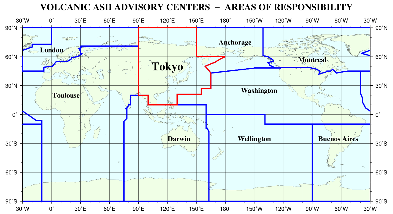
Within this framework, nine VAACs are designated around the world.
The Japan Meteorological Agency (JMA) was designated as the Tokyo VAAC in 1993, and has provided Volcanic Ash Advisories (VAAs) to the above organizations in the East Asia and Northwest Pacific regions since 1997.
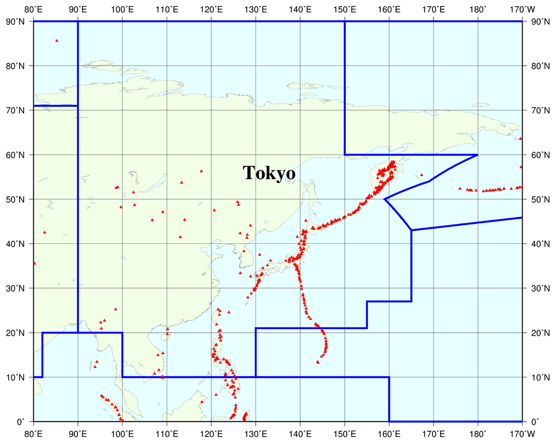
The Tokyo VAAC has extended its area of responsibility to cover East Asia, the Northwest Pacific region and part of the Arctic Circle.

Operation of Tokyo VAAC
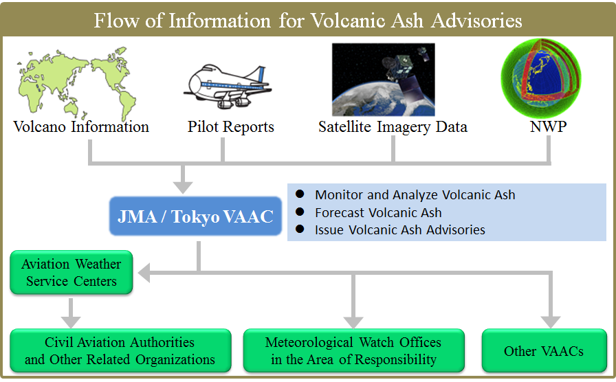
Monitoring volcanic ash clouds
Early detection of volcanic eruptions is crucial for VAAC operations.
Volcanic activities in Japan are monitored by four JMA Volcanic Observation and Warning Centers located in Sapporo, Sendai, Tokyo and Fukuoka.
The Tokyo VAAC receives volcanic activity reports from these centers when eruptions or explosions occur in domestically volcanoes.
The Tokyo VAAC also receives information on volcanic activities outside Japan from the MWOs within its area of responsibility and relevant organizations such as the Kamchatka Volcanic Eruption Response Team (KVERT), the Philippine Institute of Volcanology and Seismology (PHIVOLCS), the Alaska Volcano Observatory (AVO) and adjacent VAACs.
Volcanic eruption reports from pilots from cruising airplanes as well as satellite imagery from the geostationary meteorological satellite and the polar-orbiting satellite are also important sources of information.
Volcanic ash forecasting
Forecasting of volcanic ash movement is essential in deciding optimal flight routes.
A volcanic ash transport model developed by the Tokyo VAAC calculates the expected extent and height of volcanic ash clouds 6, 12 and 18 hours ahead based on analysis of satellite imagery and other data using the latest three-dimensional forecast atmospheric data on variables such as wind direction and speed from JMA's global numerical weather prediction system.
Volcanic ash advisory (VAA) issuance
VAACs issue VAAs describing the latest extents of volcanic ash clouds and forecasting their trajectories in both text and graphical form (as defined in ICAO Annex 3) to assist MWOs in preparing SIGMETs on volcanic ash clouds.
VAAs are updated as a minimum at six-hour intervals (normally at 00, 06, 12 and 18 UTC) for as long as ash clouds are identified in satellite imagery.
If notable changes occur in ash clouds, the VAA is updated as often as needed.
In the event that ash cloud extension is identified in satellite imagery, VAG (Volcanic Ash Graphic) and VAGI (Volcanic Ash Graphic for Initial Distribution) information is also issued.
VAAs are disseminated to airlines, aviation authorities, MWOs and other related organizations through airport branches of JMA and aviation authorities.
Tokyo VAAC's area of responsibility
Red triangles represent volcanoes as listed in the database of Smithsonian Institution's Global Volcanism Program.
Information flow of volcanic ash advisory


