Explanation on the Products for Climate System Monitoring
For most of the products in the "Climate System Monitoring" webpage, the base period for the normal is 1991 - 2020, unless otherwise noted. Anomalies are deviations from the normal. Standard deviations are calculated for the time period of the normal.
Extratropical Circulation
Atmospheric circulation data are based on the results of six-hourly global objective analysis conducted at 00, 06, 12 and 18 UTC of the Japanese Reanalysis for Three Quarters of a century (JRA-3Q; Kobayashi et al. 2021).
Wave activity flux (Takaya and Nakamura 2001) indicates the propagation of Rossby wave packets.
Kinetic energy per unit mass of high frequency variation at 500 hPa indicates the activity of synoptic scale disturbances. It is defined as half the sum of squares of zonal and meridional components of 2-8 day band pass filtered (Duchon 1979) wind speed.
Zonal averaged northward flux of eastward momentum in the upper troposphere and zonal averaged northward heat flux at 850 hPa are calculated after Newell et al. (1972).
The empirical orthogonal function (EOF) analysis is conducted with covariance matrix of latitude weighted seasonal mean 500 hPa height north of 30°N from 1948 to 2021. The eigen-vectors of the first and second modes of EOF analysis indicate the primarily and secondary dominant spatial patterns of 500 hPa height anomalies, respectively. Three month and five day mean EOF scores are calculated by projecting the corresponding 500 hPa height anomalies onto the eigen-vectors. The amplitudes of the eigen-vectors are normalized and represent the values when the variance of the seasonal mean score for the normal period is one.
Tropical Circulation and Convection
The data for monitoring tropical circulations are also the JRA-3Q data.
Convective activity is inferred from outgoing longwave radiation (OLR). It can be assumed that lower values of OLR indicate more enhanced convective activity, except for the middle latitudes in winter season and for high-altitude areas. The original OLR data are derived from the observations by the National Oceanic and Atmospheric Administration's (NOAA) polar orbital satellites, and provided by the Climate Prediction Center (CPC)/NOAA and the National Environmental Satellite, Data, and Information Service (NESDIS)/NOAA. The OLR data from CPC are used as preliminary data, and the interpolated OLR data from ESRL are used as final data. OLR-related products from 1991 onward are based on NOAA CPC Blended OLR (CBO). Depending on the availability of NOAA CPC Blended OLR (CBO) data, updates may be delayed or figures may be filled with gray indicating data missing.
OLR maps represent the strength of longwave radiation from the earth's surface under clear sky conditions into space or from the top of clouds under cloudy conditions into space for monitoring of convective activity. It can be assumed that lower values of OLR indicate more enhanced convective activity under cloudy conditions. It should be noted that lower values of OLR can represent lower surface temperatures, but not the top of clouds, in the middle latitudes in winter season and in high-altitude areas (e.g., the Tibetan Plateau).
According to Helmholtz's theorem in vector analysis, horizontal wind can be decomposed into rotational and divergent components. Using the stream function, the rotational component can be written as
A positive stream function anomaly indicates stronger (weaker) clockwise (counter-clockwise) circulation than the normal, and vice versa.
Using the velocity potential, the divergent component can be written as
A positive velocity potential anomaly indicates stronger (weaker) large-scale convergence (divergence) than the normal, and vice versa. The equatorial intra-seasonal variation associated with the Madden-Julian Oscillation (MJO) can be determined from the time-longitude cross section of the five-day mean 200-hPa velocity potential.
Tropical Atmospheric and Oceanic Monitoring Indices
Monthly mean sea level pressure anomalies for Darwin, Australia and Tahiti in the southern Pacific are based on CLIMAT reports. The Southern Oscillation Index (SOI) is defined as the normalized difference between Tahiti and Darwin of monthly mean sea level pressure anomalies normalized by their standard deviations.
Equatorial zonal wind indices are defined as area-averaged zonal wind anomalies normalized by their standard deviations.
OLR indices are defined as area-averaged OLR anomalies with reverse sign, normalized by their standard deviations. It should be noted that positive and negative values of the OLR indices indicate enhanced and suppressed convective activity, respectively, compared to the normal.
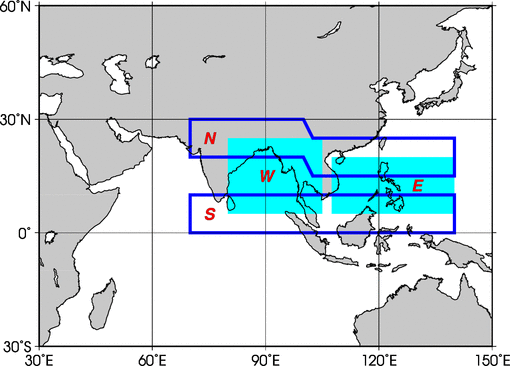
Asian summer monsoon OLR indices (SAMOI) are derived from OLR anomalies from May to October. SAMOI (A), (N) and (W) indicate the overall activity of the Asian summer monsoon, its northward shift and westward shift, respectively. The SAMOIs definitions are as follows:
SAMOI(A)=W+E, SAMOI(N)=N-S, SAMOI(W)=W-E
W, E, N and S indicate area-averaged OLR anomalies for the respective areas shown in Figure 1, normalized by their standard deviations.
The El Niño monitoring indices are regional mean value of 1° x 1° SST analyses for the four El Niño monitoring regions.
Fig. The areas of Summer Asian Monsoon OLR Indices (SAMOI)
Oceanographic Conditions
Sea surface temperatures (SSTs) are based on COBE-SST2 (Hirahara et al. 2014) and MGDSST datasets. Ocean heat content (OHC) is determined using five day mean datasets of MOVE/MRI.COM-G3.
Time series of SST, subsurface temperature, OHC and so on along the equator, 6°N and 6°S for the last three or five years are shown in order to monitor the tropical oceanographic conditions related to El Niño/La Niña events.
The depth of 20°C isotherm along equator is roughly equivalent to the depth of thermocline there. The surface zonal wind stresses is used to drive the ocean general circulation model of the MOVE-G3. The value of OHC is equivalent to averaged temperature from the surface to the depth of 300 m.
Snow Cover
Statistics on the number of snow cover days are based on an algorithm developed by the Japan Meteorological Agency (JMA 2011), derived from data by the Special Sensor Microwave Imager (SSM/I) and the Special Sensor Microwave Imager Sounder (SSMIS) on board US Defense Meteorological Satellite Program (DMSP) satellites (from January 1989 onward) and the Advanced Microwave Scanning Radiometer 2 (AMSR2) on board JAXA (the Japan Aerospace Exploration Agency) GCOM-W (Global Change Observation Mission - Water) satellite (from November 2016 onward).
The number of days of snow cover is also analyzed using CLIMAT and SYNOP reports.